


Cool Water Exchange — San Luis Pass Area
Story by Bill L. Olson
Texas Outdoors Journal readers regularly read coastal editors reference finding cooler water near passes and jetties because of the exchange with cool temperatures found in the Gulf of America during the heat of summer. I have admitted for most of my coastal fishing experience my search begins with folding laminated nautical charts and maps. The reason is simple. Those larger reference tools can be spread out on a table to review the surrounding area to better understand how shorelines, channels, structure, prevailing winds and other factors interact with each other.
It has long been said the deeper Gulf warms in the winter and cools in the summer because of its fairly-static temperature range. On the other side of this discussion shallow water warms and cools more quickly, and sometimes dramatically.
This month’s clip takes a look at an area I have respected, been intrigued and fish most of my life — San Luis Pass. The respect is what I pay to water in general and around passes in particular. Changing of tides and currents can become dangerous for the uninformed, inexperienced and careless.
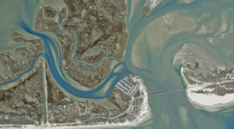
Away from the pass are satellite bays, grassy shorelines, soft mud and hard sand bottoms, sandy shoals, reefs plus gateways to other attractive waterbodies. The accompanying images show a detail of the general San Luis Pass area with the bridge that connects west Galveston Island to Follet’s Island that leads to Freeport.
************************************************************************
To read more, click here to SUBSCRIBE